Let’s talk trash. August 13, part 1

One of the big concerns through the northwest…Canada and Alaska…is bears getting at our food.  As they say, “A fed bear is a dead bear.”  If a bear connects humans with food  it can easily translate into an attack.  If that happens, the dead is hunted down and killed.  Almost everywhere, there are trash barrels designed to eliminate the bears ability to get at the trash.  You have to unlatch the top to put trash in it.  Obviously, bears can do that but maybe a raccoon?

Since my last posting on Thursday when I was in Tok, I’ve left Alaska and traveled through part of the Yukon and into British Columbia.  By the end of today, I’ll be in Alberta.

When I left Tok, I took the Top of the World Highway through Chicken to Dawson City.  Chicken was originally going to be called Ptarmigen for the Alaska state bird but no one knew how to spell it so they said it tasted like chicken so let’s call it “Chicken”.  I don’t know if the story is true but it’s told by everyone throughout Alaska.  One lady clerk at a gift store told me that’s what she had been told for 40 years.

Dawson City is a unique town.  As you approach the town on the highway, the road ends and you have to take the ferry about ten minutes across the river to town.  The ferry carries 2-3 motorhomes and a couple of cars per trip.  I had about a twenty minute wait and I was in town.

Town is kind of a throw back to the Klondike days. I took some pictures, grabbed a sandwich, and headed south.  It seemed a little more authentic that Skagway but cruise ships don’t come here.  Tour buses from the cruise lines do.

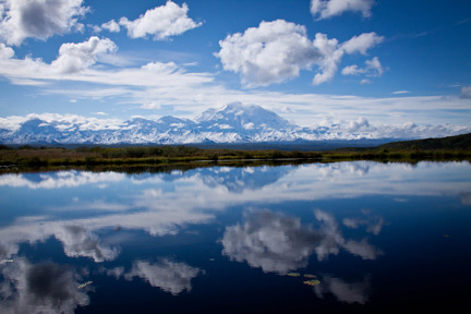
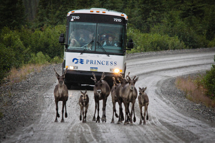
I arrived in Watson Lake on the Yukon-BC border about 8:30pm Thursday night.  I had been thinking that I’d like to get some bison pictures and was going over a brochure I’d picked up at the visitor’s center earlier in the day.  It looked like the best place was at MacKenzie River Bison Sanctuary.  It’s in the Northwest Territories near Yellowknife.  The tourist office in Watson Lake was closed when I got in.  I stopped at the Northern Lights Centre across the street which was still open.  Two high school boys manning the gift store there took me into the office and we looked up MacKenzie River and found it would take about 23 hours from Watson Lake.  One of the guys said you could do that or you could drive down the road about 20 minutes and you’ll see a herd of them.  Let’s see 23 HOURS or 20 MINUTES.

I decided to spend the night and start out the next morning to hunt bison.  Plus there was something else in town I wanted to photograph.

It’s the Sign Post Forest.

In 1942 a homesick U.S. Army soldier from Danville, Ohio was here working on the Alaska Highway.   He put up a sign pointing the way to his hometown with the mileage.  Others followed his lead.  In 1990, another Ohio couple put up the 10,000th sign.  In 1992, the original soldier came back to celebrate the 50th anniversary of the Sign Post Forest.  A lady in the visitor’s center told me that today there are more than 73,000 signs!

Some have made several trips.

Now, to find those buffalo….

Posted in Alaska | Leave a comment

Mt. McKinley revisited -August 11, Part 2

One of the things you get to do while driving long distances is think about what you said in your posting and what you wish you had said.  I’ve done a lot of that.  As of right now, I’m close to 8000 miles since July 5.  I’m in Whitehorse, Yukon at noon and I’m headed for Wood Bison National Park in hopes of getting some bison shots.  That won’t happen for probably two days though.

Anyway, back to thinking about what you’d liked to have said after you’ve posted.

When I got up on Saturday morning at 5:15am and saw Mt. McKinley, it was AMAZING.  It’s hard to adequately show the immense dominance of the mountain.  Pictures don’t do it justice.  I’ve visited several photo galleries in Alaska and many have great shots of the mountain but none of them capture its magnitude.

As a reminder, here are two shots I’ve previously posted.

When I saw the mountain on Saturday morning, you had the feeling you could reach out and touch it or certainly drive a mile or two and be there.  Actually, the first shot…sunrise….is 27 miles away.  That’s as close as you can drive to it.  The second shot is from the Eielson Visitor Center is 33 miles away.

I’ve been trying to come up with an analogy to explain how big it is.  For example, we’ve all probably seen pictures of the World Trade Center towers prior to 9/11 taken from the New Jersey shore and how they dominated the skyline of lower Manhattan.  I believe the World Trade Center was 110 stories at 11’ per story that puts its height at about 1200 ft.  That would make Mt. McKinley about 15 times taller and it would cover virtually all of NYC.  Imagine how that would look from the Jersey shore. The mountains around McKinley are between 4-10,000 feet.  A couple are 12,000 and 16,000 ft.  That means the majority are half the size of McKinley.

Another analogy is to imagine a group of 4-6-year-old kids standing on stage in front of a curtain.  Now imagine the curtain opening and a lineman for a NFL team in football gear steps between them.  He’s going to be twice as big as some of those kids and a third again as big as some of the older ones.  That’s the dominance of Mt. McKinley.

Pike’s Peak in Colorado is about 14,000 feet.  McKinley is a MILE Plus taller.

That’s it for today.  I’m going to check my guide to see what I do around Whitehorse or if I move on.  I want to spend a couple of days around Jasper National Park, Lake Louise and Banff in Alberta before meeting Jean in Great Falls, MT on Saturday, August 20.

I appreciate everyone’s comments and notices when the posting doesn’t go exactly as planned.  My son, Derek, is usually first with “Dad, it took me to the last post” or “Dad, it cut off your post”.

Now, I try to check for those things before I send out my notification.  Something I should have done anyway.

Also, it’s never too late to add someone to this blog.  If you know someone that would enjoy reading it and/or seeing the pictures don’t hesitate in forwarding the link to them or send me an email at rgates002@gmail.com and I’ll add them to the mailing.  They can always go back to any of the earlier posts.

Thanks again until next time….

Posted in Alaska | Leave a comment

Denali Caribou Kill revisited- August 11

I wanted to revisit the picture I sent last Saturday, I believe of the bear laying on the caribou kill in Denali.

As you recall, this caribou was taken down by two wolves on Thursday of last week.  The bear basically stole the kill and after gorging himself buried the kill and plopped himself down on it to protect it.  This picture was taken on Friday afternoon as we returning to camp from Wonder Lake.  (We had missed the scene on the way out.)

On Sunday, the bear was moving about the river bed away from the carcass.  Look at the claws on this bear.

Here’s another shot.

On Monday, we were headed back to camp about 4:30pm when we came up the same kill.  First, here is a wolf that wants whatever is left of that caribou for himself/herself.

The wolf kind of blends in with the river bed but it’s about a third of the way into the frame on the left near the middle.

Our bear friend returns to block the access for the wolf.

Then he returns to clean off the antlers….

I’m going to post another entry shortly.  I am trying to avoid having these cut-off part of my posts.

Posted in Alaska | Leave a comment

Mt McKinley – August 10 Part 2

Picking up where it cut off….

Alaskans thought the name, McKinley, was irrelevant and in 1975 petitioned Congress to change the name back to Denali.  In 1980, Congress did that…changing the name of the park to Denali National Park and Preserve and enlarged the area to 6 million acres.  Bus one Ohio congressman was able to keep Congress from changing the name of the mountain itself by using a little known rule.  Because McKinley was a former governor and congressman from Ohio a successor in his district he wanted the mountain to remain McKinley.  He was able to block the change of the mountain’s name.  Thus the mountain is still Mt. McKinley, officially.

I made three trips to Wonder Lake during my five days at Denali.  The first was to camp on Friday and I’ve already posted a picture of that sunrise on Saturday morning.  On Sunday, it snowed heavily once we reached the 3000 ft. level and it was so cloudy you couldn’t see across the valley to any of the mountain range.

My friends in Buffalo won’t find this picture any big deal since we had this kind of snow all the time.  But not in August.

After we reached Wonder Lake the skies cleared.  The sun came out and this is what we got.

On Monday, I made my third trip to Wonder Lake with the hope of getting a shot of the mountain reflected in Reflection Pond.  It is a 3/4 mile hike off the main road and then a 1/2 mile hike to the lake through tiaga…spongy, tundra.  Going down to the lake wasn’t too bad but the climb back up left me wondering if I was going to have a coronary.  I was sweating profusely and breathing hard.  Walking up on the tiaga was very difficult…at least for me.

Everything needs to fall into place.  No wind so the pond is as smooth as glass, sunny skies and the mountain needs to be visible, obviously.  I made the hike with another photographer I met on the bus from Clemson, SC.  Here’s the result.

Every year a large number of climbers attempt to summit the mountain.  They are required to submit an application with a resume of their climbing experience.  The park service can’t refuse anyone from attempting the climb but they do try to discourage climbers who don’t have the experience they feel is necessary to make it.  The climbing season is mid-April to mid-July.  This year 1204 climbers started the climb and just over half made it.  Fifty-three percent to be exact.  Seven died.

The preferred climb is from the southern side.  The climbers are airlifted to base camp at approximately 7000 feet then they have a 15 mile trek to the top that takes about three weeks.  They climb a ways, cache their supplies at one height, retreat lower to acclimate.  Then they climb to their cache and move it higher. Then retreat to a lower level and go through this process over and over again.  In all they probably hike 100 miles to cover the 15 to the top.

Climbers are required to be able to self-rescue.  When that can’t happen, there is a team of Climbing Rangers that stay on the mountain for 30 days at a time to handle rescues.  Every 30 days they rotate off to another group.  If the Climbing Rangers can’t handle the rescue, there are high altitude helicopters available and finally, the Army will come at the last minute as part of a training exercise if all else fails.

On our two trips on Sunday and Monday we saw some interesting wildlife including the bear that had thrown his body on top of the caribou that I sent along on Saturday’s post.

I’ll pick that up next time.

Posted in Alaska | 1 Comment

Mt. McKinley – August 10

I departed Denali National Park yesterday about noon and drove 12 hours to Tok on my way back to the Yukon, British Columbia, Alberta and the Lower 48.  I hope to see bison today and maybe some more moose.

Last night at about 9pm I was about two hours from Tok when I spotted a moose cow and her calve in a small pond beside the road.  I did a U-turn and when back and passed the location.  Did another U-turn to put the moose on the driver’s side of the truck and crossed to the shoulder going the wrong way on the highway.  There was almost no traffic and I wasn’t worried about being hit.  I put my window down and got my camera ready before pulling up the the moose’s location.  Here’s what I got.

Moose rump!  They took off for the trees.  So I decided to add a new tool to my photographic arsenal…patience.  I went up the road 100 yards and turned around again and came back to the spot they had previously been at.  I put down my passenger window, turned off the truck and waited.  The shot above was taken at 9:03 pm.  This one was taken at 9:24 pm.

They came back.  I sat there for about 10 minutes watching them eat.  They eventually moved apart.  When I started up the truck to leave the noise sent them back into the trees but I imagine after I was down the road a ways, they were back at their watering hole.In my last blog, I showed you a picture of Mt. McKinley at sunrise on Saturday.  I like to tell you a little about Mt. McKinley and show you some additional pictures.

The mountain was known as Mt. Denali by the Athabascan natives.  Denali means “the High One” in their language.  In 1896 a businessman and Princeton graduate was prospecting in the area.  When he came out in 1898 he called the mountain McKinley for President William McKinley in an article published in the New York Sun.  The name stuck but Alas

Posted in Alaska | Leave a comment

Wonder Lake- Denali National Park -August 6

I woke up this morning to 35 degrees and this….

This is Mt. McKinley, 20,320ft., yesterday when I arrived you couldn’t see where it was due to the heavy cloud cover.  Obviously,  I was disappointed but this morning at 5:15am this is what it looked like.  Only about a a third of the visitors to the park actually see Mt. McKinley due to the cloud cover so I feel very fortunate.

My tent is the orange one in the upper left.  This is the Wonder Lake Campground and you can only tent camp here and you have to ride the park bus in.  We had a full load of campers.

It took us 4 1/2 hours to make the 85 mile drive.  We stopped three times at rest stops for bathroom breaks and at a visitor’s center that is about 65 miles into the park.   Vehicles can’t drive beyond 12 miles unless you have a pass to camp at the Teklanika Campground.  That’s where I’d headed now for three days.  That’s 30 miles into the park.

On our way back this morning we saw a couple of grizzlies.  Here’s one of them.

Just around the bend, we came upon this grizzley sleeping on top of a caribou that a couple of wolves had killed on Thursday.  The bear has claimed what’s left of the carcass.  You can see the antlers from the caribou.

That’s going to be it for today.  I need to get back to the campground to get my spot.  I’ll have my next posting either Tuesday late or Wednesday.

Posted in Alaska | Leave a comment

Denali National Park- August 5

I arrived at Denali National Park yesterday afternoon after three days of rain in Talkeetna.  I have to catch a camper bus in 45 minutes to Wonder Lake Campground.  It is 85 miles into the park.  There are a couple of lodges 89 miles in where rooms rent for $450 per night.  I’m staying in the campground for a senior citizen rate of $8.

Last night I was at a campground near the entrance to the park.  Tomorrow I’ll return to the entrance to pick up my vehicle and then drive back into the park 30 miles where I’ll stay three nights.

I don’t know what kind of internet service there is at any of these locations so you may not have another post until I get back to the entrance.  Depending on the time, I’ll try and post tomorrow when I come back from Wonder Lake.

Posted in Alaska | Leave a comment

Denali Highway- August 2 posting

Yesterday I drove the Denali Highway between Paxson and Cantwell.  It’s 134 miles of gravel road.  The first 12 or so are paved but after that it is a gravel, washboarded highway.   Most of the time I was driving 25-30 miles an hour.  Sometimes because I was looking for wildlife and others because you just couldn’t drive a whole lot faster.  I didn’t see any bear along this road but I did see lots of caribou.

Caribou are hard to photograph because they are very skittish.  They head for cover when you see them on the road.  Then you can’t find them when you slowly move up to where you think they went into the bush.  Here are a variety of scenes I shot along this stretch of road. Bear in mind it was rainy and overcast all day.

The flower in the foreground is fireweed. The story is that when the bloom reaches the top then summer is over.

Here are a couple of shots of some loons on another lake.  While I was shooting these an eagle circled and was planning on making lunch of one of these loons.  The two loons made all kind of weird noises and ducked below the water and the eagle moved on for the time being.

I first saw this group of caribou in the tundra moving down a trail but couldn’t get a clear shot.  I had pulled off onto an old mining road and was about a mile off the Denali Highway at the time.  I moved up the road a ways and waited, hoping that they would eventually cross the road.  And they did.

Finally, in Texas they still heard cattle by horseback and some ranchers use helicopters.  I’ve never seen a round-up done with a tour bus but this one is moving seven caribou down the road right toward me.  I took a number of shots before they eventually moved off down a trail.  Now, I’m going to try and sell this shot to Princess Cruises for their brochure.  Maybe they’ll help pay for that transmission I replaced in Wyoming.

I met a local at the library this morning while I was using the wi-fi and he suggested a road up into the mountains that would provide me with some great scenery.  I’m going to go look for it.  I’m waiting for the weather to clear (?) for a flightseeing trip over Mt. McKinley.  Hopefully, that will happen in the next 48 hours.  More later…..

Posted in Alaska | Leave a comment

North Pole – August 1, part 2

Sunday, I drove south of Fairbanks to North Pole, Alaska.  As you might guess, it is a 12 month celebration of Christmas.

This a year-round Christmas store.  The town has themed light poles, too.

Even the federal government gets involved.

Here’s the BIG guy himself.

Things can get pretty hectic as Santa and elves work toward their deadline.  The elves need some place to unwind.

A number of local businesses have got into the spirit, too.

When Santa finally decides to hang up the ‘ole sack and retire, he’s going to need a place to go.

But until or if that day ever comes, Santa has decided he needs to diversify.  Like ski and bike shops, the need to plan for the off season is important.  Santa has apparently found his niche.

Today, Monday, I drove the Denali Highway.  It’s 134 miles of mostly gravel and it’s beautiful.  I’m have pictures tomorrow.

Posted in Alaska | Leave a comment

Dalton Highway- August 1

Change of plans…..

Saturday I had planned to drive all the way to Prudhoe Bay on the Dalton Highway.  I started the drive late in the afternoon after driving to Fairbanks from Wasilla.  The road starts out paved for about 70 miles then turns to gravel.  The Alaska Pipeline runs parallel to the highway beginning in Prudhoe Bay and ending at Valdez at the port.

Anyway, I started here…at the visitor’s center for the pipeline.  In the cutaway shot, you’ll see an example of the inside of the pipeline.

The oil travels the length of the pipeline but with it are “pigs” that perform varies jobs.  This example helps smooth the flow of the oil and cleans the inside of the pipeline, too.  Other “pigs” are magnetized and measure the change in the thickness of the pipe.  There are also other “pigs” that perform other technical jobs.

Some places along the Dalton, the pipeline runs close to it and is clearly visible.

Other places it’s some distance from the highway hidden by the trees.  The primary purpose for the highway is to be a haul road for supplies to the oil refinery at Prudhoe Bay.  If you drive the entire length of the highway, it ends in Deadhorse and in order to see the Artic Ocean you must sign up for a 2-hour, $45 tour and reserve a minimum of 24 hours in advance with your name and either driver’s license or passport information so the BP can do a security check.

This photo doesn’t due justice to the term “gravel” road.  It was raining (surprise, surprise) on Saturday.  My truck was covered in mud about a mile into the trip.

Anyway, I decided that I was going to end my drive at the Arctic Circle.  Most of the road was driven at between 35-40 miles per hour.  Occasionally, I could push it to 50.  Most of the trucks were doing 50 or better.

I wanted to get to the Arctic Circle before dark so I could take a picture.  This was a 10:30pm.  It’s still light out.

My map showed a dotted line where the Arctic Circle was but all I found was this sign.

I headed south and camped about 15 miles south of the circle.  I was warm but it got a little cooler than most of the other nights I’ve been out.

Along the coast and in Anchorage it gets cold but not as cold as it gets more inland in Fairbanks.  Winters there can get -50.  Sounds delightful!!!!

By the way, this isn’t an electric car.  This is how they keep them warm enough to start in the morning.

On my next blog, we’re going to visit the North Pole.

Posted in Alaska | Leave a comment